Our website is made possible by displaying online advertisements to our visitors.
Please consider supporting us by disabling your ad blocker.
Noirmoutier
You can help expand this article with text translated from the corresponding articles in French and Spanish. (December 2009) Click [show] for important translation instructions.
|
 Noirmoutier Island image from satellite Spot | |
| Geography | |
|---|---|
| Location | Atlantic Ocean |
| Coordinates | 46°58′N 2°13′W / 46.967°N 2.217°W |
| Area | 49 km2 (19 sq mi) |
| Length | 19 km (11.8 mi) |
| Width | 6 km (3.7 mi) |
| Highest elevation | 20 m (70 ft) |
| Highest point | No named |
| Administration | |
France | |
| Region | Pays de la Loire |
| Department | Vendée |
| Arrondissement | Les Sables-d'Olonne |
| Demographics | |
| Population | 9,590 |
| Pop. density | 195.76/km2 (507.02/sq mi) |
| Ethnic groups | French people |
| Official name | Marais Breton, Baie de Bourgneuf, Ile de Noirmoutier et Forêt de Monts |
| Designated | 2 February 2017 |
| Reference no. | 2283[1] |

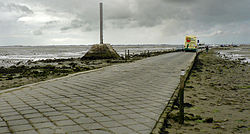
Noirmoutier (also French: Île de Noirmoutier, pronounced [nwaʁmutje]; Breton: Nervouster, Nermouster) is a tidal island off the Atlantic coast of France in the Vendée department (85).
- ^ "Marais Breton, Baie de Bourgneuf, Ile de Noirmoutier et Forêt de Monts". Ramsar Sites Information Service. Retrieved 25 April 2018.
Previous Page Next Page


