Our website is made possible by displaying online advertisements to our visitors.
Please consider supporting us by disabling your ad blocker.
North Canadian River
| North Canadian River | |
|---|---|
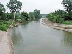
 The North Canadian River near Yukon, Oklahoma | |
 Map of the Canadian River watershed showing the North Canadian River | |
| Location | |
| Country | United States |
| States | Oklahoma |
| Physical characteristics | |
| Source | Confluence of Beaver River and Wolf Creek |
| • location | Woodward County |
| • coordinates | 36°35′20″N 99°30′06″W / 36.5889236°N 99.5017789°W[1] |
| • elevation | 1,952 ft (595 m)[2] |
| Mouth | Eufaula Lake, Canadian River |
• location | McIntosh County |
• coordinates | 35°22′30″N 95°36′36″W / 35.3750995°N 95.6099852°W[1] |
• elevation | 581 ft (177 m)[1] |
| Length | 800 mi (1,300 km) |
| Basin size | 17,955 square miles (46,500 km2) |
| Discharge | |
| • location | Wetumka |
| • average | 834 cu ft/s (23.6 m3/s)[3] |
 | |
The North Canadian River is a river, 440 miles (710 km) long,[4] in Oklahoma in the United States. It is a tributary of the Canadian River, draining an area of 17,955 square miles (46,500 km2)[5] in a watershed that includes parts of northeastern New Mexico and the Texas Panhandle.[6]
A seven-mile (eleven-kilometer) portion of the river flowing through Oklahoma City was renamed the Oklahoma River in 2004.[6]
- ^ a b c Cite error: The named reference
GNISwas invoked but never defined (see the help page). - ^ Cite error: The named reference
GNIS2was invoked but never defined (see the help page). - ^ "USGS Surface Water data for Oklahoma: USGS Surface-Water Annual Statistics".
- ^ United States Board on Geographic Names (1970-11-10). "North Canadian River". Retrieved 2019-09-25.
- ^ U.S. Geological Survey. National Hydrography Dataset/Watershed Boundary Dataset, area data covering North Canadian River watershed (4-digit Hydrologic Unit Codes 1110), viewed in The National Map, accessed 2019-09-25
- ^ a b "The National Map". viewer.nationalmap.gov. Retrieved 2019-09-25.
Previous Page Next Page


