Our website is made possible by displaying online advertisements to our visitors.
Please consider supporting us by disabling your ad blocker.
North Cascades National Park
| North Cascades National Park | |
|---|---|
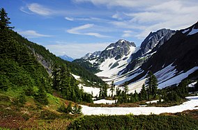
 Cascade Pass and Pelton Basin | |
| Location | Whatcom, Skagit, and Chelan counties, Washington, U.S. |
| Nearest city | Sedro-Woolley, Washington |
| Coordinates | 48°49′58″N 121°20′51″W / 48.83278°N 121.34750°W[1] |
| Area | 504,654 acres (2,042.26 km2)[2] |
| Established | October 2, 1968 |
| Visitors | 30,154 (in 2022)[3] |
| Governing body | National Park Service |
| Website | North Cascades National Park |
North Cascades National Park is a national park of the United States in Washington. At more than 500,000 acres (200,000 ha), it is the largest of the three National Park Service units that comprise the North Cascades National Park Complex. North Cascades National Park consists of a northern and southern section, bisected by the Skagit River that flows through the reservoirs of Ross Lake National Recreation Area. Lake Chelan National Recreation Area lies on the southern border of the south unit of the park. In addition to the two national recreation areas, other protected lands including several national forests and wilderness areas, as well as Canadian provincial parks in British Columbia, nearly surround the park. North Cascades National Park features the rugged mountain peaks of the North Cascades Range, the most expansive glacial system in the contiguous United States, the headwaters of numerous waterways, and vast forests with the highest degree of flora biodiversity of any American national park.
The region was first settled by Paleo-Indian Native Americans; by the time European American explorers arrived, it was inhabited by Skagit tribes. By the early 19th century, the region was visited by fur trappers and several British and American companies vied for control over the fur trade. After the Canada–United States border was set at the 49th parallel in 1846, explorers came to chart potential routes through the mountains for roads and railroads. Limited mining and logging occurred from the late 19th century to the early 20th century. The first significant human impact in the region occurred in the 1920s when several dams were built in the Skagit River valley to generate hydroelectric power. Environmentalists then campaigned to preserve the remaining wilderness, culminating on October 2, 1968, with the designation of North Cascades National Park.
Heavy snows and a high risk of avalanches due to the steep terrain, especially on the western slopes, severely limit visitation in the winter. Most access to the park is from State Route 20, which follows the Skagit River, though even this road is closed for months at a time in the winter. Most of the plant and animal species native to the park region are still found there, though climate change and pollutants from industrialized regions to the west pose risks to the environment. The park has one of the earliest and longest lasting research programs dedicated to studying climate change, primarily through examining the effects of glacial retreat.
North Cascades National Park is almost entirely protected as wilderness, and so the park has few structures, roads or other improvements. Visitors wishing to drive to a campground must do so in the adjacent national forests or national recreation areas. Camping inside the park requires hiking in by trail, horseback or boat, and camping is regulated by a permit system to ensure the wilderness is not over-exploited. Mountaineering is popular in the park and only unobtrusive clean climbing is allowed.
- ^ "North Cascades National Park". Geographic Names Information System. United States Geological Survey, United States Department of the Interior. Retrieved March 29, 2014.
- ^ "Listing of acreage – December 31, 2011" (XLSX). Land Resource Division, National Park Service. Retrieved March 29, 2018. (National Park Service Acreage Reports)
- ^ "NPS Annual Recreation Visits Report". National Park Service. Retrieved March 23, 2023.
Previous Page Next Page
منتزه شمال كاسكيدز الوطني Arabic Parque nacional de les Cascaes del Norte AST Taman Nasional Cascades Kalér BAN Parc Nacional de les Cascades del Nord Catalan North Cascades National Park CEB Národní park Severní Kaskády Czech North Cascades National Park Danish North-Cascades-Nationalpark German Parque nacional de las Cascadas del Norte Spanish Põhja-Kaskaadide rahvuspark ET


