Our website is made possible by displaying online advertisements to our visitors.
Please consider supporting us by disabling your ad blocker.
North Jutlandic Island
Native name: Nørrejyske Ø | |
|---|---|
 The Grenen sand bar at the northern tip of the island | |
 | |
| Geography | |
| Location | Skagerrak |
| Coordinates | 57°6′N 9°30′E / 57.100°N 9.500°E |
| Area | 4,685 km2 (1,809 sq mi) |
| Administration | |
| Region | North Denmark Region |
| Largest settlement | Hjørring (pop. 24,963) |
| Demographics | |
| Population | 294,424 (2020) |
| Pop. density | 63.32/km2 (164/sq mi) |
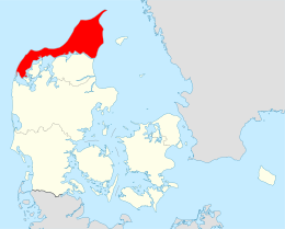
The North Jutlandic Island (Danish: Nørrejyske Ø), Vendsyssel-Thy, or Jutland north of the Limfjord (Jylland nord for Limfjorden) is the northernmost part of Denmark and of Jutland. It is more common to refer to the three traditional districts of Vendsyssel, Hanherred, and Thy. The area has been intermittently a tied island and, during modern times, was not surrounded by water until a storm in February 1825, which severed the region from the remainder of Jutland and caused a water connection between the North Sea and the western end of the Limfjord.[1] Hence, it retains its traditional status as a part of Jutland even though, geographically, it is instead a separate island.
By area, it is the second-largest island of Denmark after Zealand (excluding Greenland), with a population of 294,424 on 1 January 2020.[2] 309,834 people lived on the island in 1981.
Danes rarely refer to the area as a whole, but more often to the three constituent districts or to North Jutland (which also includes an area south of the Limfjord). The adjectives nordenfjords and søndenfjords are also commonly used, meaning north and south of the fjord, respectively. The names can all be considered ad hoc creations, as a traditional name for the island is lacking.
The island has seven fixed transport links to the mainland (four road bridges, one road tunnel, and two rail bridges). There are also two car ferry connections.
- ^ "Stormfloden i 1825, Thyborøn Kanal og kystsikring" [The flood in 1825, Thyborøn Channel and coastal protection]. danmarkshistorien.dk (in Danish). Aarhus University. Retrieved 13 June 2020.
- ^ "Danmarks Statistik." Retrieved 12 May 2020.
Previous Page Next Page


