Our website is made possible by displaying online advertisements to our visitors.
Please consider supporting us by disabling your ad blocker.
Northeast (Washington, D.C.)
Northeast | |
|---|---|
Quadrant | |
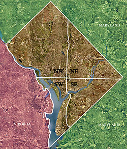
 Color-enhanced 2002 USGS satellite image of Washington, D.C. The crosshairs in the image mark the quadrant divisions of Washington, D.C., with the United States Capitol at the center of the dividing lines. To the west of the Capitol is the National Mall, which is visible as a slight green band in the image. The Northwest quadrant is the largest, located north of the National Mall and west of North Capitol Street. | |
 | |
| Country | United States |
| District | Washington, D.C. |
Northeast (NE or N.E.) is the northeastern quadrant of Washington, D.C., the capital of the United States. It encompasses the area located north of East Capitol Street and east of North Capitol Street.
Previous Page Next Page


