Our website is made possible by displaying online advertisements to our visitors.
Please consider supporting us by disabling your ad blocker.
Northwood, New Zealand
Northwood | |
|---|---|
 Northwood Estate | |
 | |
| Coordinates: 43°27′29″S 172°36′58″E / 43.458°S 172.616°E | |
| Country | New Zealand |
| City | Christchurch |
| Local authority | Christchurch City Council |
| Electoral ward | Harewood |
| Community board | Waimāero Fendalton-Waimairi-Harewood |
| Area | |
| • Land | 723 ha (1,787 acres) |
| Population (June 2024)[1] | |
• Total | 4,560 |
| McLeans Island | Belfast | |
|
|
Bottle Lake | |
| Harewood | Casebrook | Redwood |
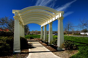
Northwood is a suburb on the northern outskirts of Christchurch city. It was developed in 2000 as a subdivision of Belfast on land previously used for apple orchards.[2][3] The name "Northwood" was accepted at a meeting of the Shirley-Papanui Community Board on 2 February 2000.[4][5]
Farmland north-west of what later became Northwood was developed into Peppers Clearwater Resort in 1998.[6]
The Groynes is a large park between Northwood and Clearwater.[7] Styx Mill Conservation Reserve is on the south side of Northwood.[8]
- ^ "Aotearoa Data Explorer". Statistics New Zealand. Retrieved 26 October 2024.
- ^ "Community profile - November 2014 - Belfast" (PDF). Christchurch City Council. November 2014.
- ^ Steeman, Marta (7 January 2014). "Apple Fields founder Kain dies". The Press.
- ^ "Proposed New Right of Way and Road Names" (PDF). Christchurch City Council. 2 February 2000.
- ^ "Christchurch Street Names: N - O: Northwood Boulevard" (PDF). Christchurch City Libraries. Retrieved 5 September 2021.
- ^ "History". Clearwater Golf Club. 2016.
- ^ "The Groynes". Christchurch City Council. Retrieved 5 September 2021.
- ^ "Styx Mill Conservation Reserve". Christchurch City Council. Retrieved 5 September 2021.
Previous Page Next Page


