Our website is made possible by displaying online advertisements to our visitors.
Please consider supporting us by disabling your ad blocker.
Notre-Dame-des-Prairies
Notre-Dame-des-Prairies | |
|---|---|
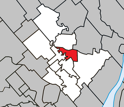
 Location within Joliette RCM. | |
| Coordinates: 46°03′N 73°26′W / 46.050°N 73.433°W[1] | |
| Country | |
| Province | |
| Region | Lanaudière |
| RCM | Joliette |
| Constituted | January 1, 1957 |
| Government | |
| • Mayor | Suzanne Dauphin |
| • Federal riding | Joliette |
| • Prov. riding | Joliette |
| Area | |
• Total | 18.80 km2 (7.26 sq mi) |
| • Land | 18.20 km2 (7.03 sq mi) |
| Population (2016)[3] | |
• Total | 9,273 |
| • Density | 509.4/km2 (1,319/sq mi) |
| • Pop 2011-2016 | |
| • Dwellings | 4,396 |
| Time zone | UTC−5 (EST) |
| • Summer (DST) | UTC−4 (EDT) |
| Postal code(s) | |
| Area code(s) | 450 and 579 |
| Highways | |
| Website | www |
Notre-Dame-des-Prairies (French pronunciation: [nɔtʁə dam de pʁɛʁi]) is a town in the Lanaudière region of Quebec, Canada, part of the Joliette Regional County Municipality. It is a suburb of Joliette, located along the eastern shores of the L'Assomption River.
Previous Page Next Page
نورت دام ديس برايريس (كيبك) Arabic Notre-Dame-des-Prairies ATJ Notre-Dame-des-Prairies (lungsod) CEB Notre-Dame-des-Prairies Spanish Notre-Dame-des-Prairies ET Notre-Dame-des-Prairies (Quebec) EU نوتر-دام-ده-پرری، کبک FA Notre-Dame-des-Prairies French Notre-Dame-des-Prairies, Québec HAK Notre-Dame-des-Prairies Italian


