Our website is made possible by displaying online advertisements to our visitors.
Please consider supporting us by disabling your ad blocker.
Numurkah
| Numurkah Victoria | |||||||||||||||
|---|---|---|---|---|---|---|---|---|---|---|---|---|---|---|---|
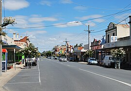
 Melville St, the main street of Numurkah | |||||||||||||||
| Coordinates | 36°05′0″S 145°26′0″E / 36.08333°S 145.43333°E | ||||||||||||||
| Population | 4,768 (2017 census)[1] | ||||||||||||||
| Established | 1868 | ||||||||||||||
| Postcode(s) | 3636 | ||||||||||||||
| Elevation | 108 m (354 ft) | ||||||||||||||
| Location |
| ||||||||||||||
| LGA(s) | Shire of Moira | ||||||||||||||
| State electorate(s) | Shepparton | ||||||||||||||
| Federal division(s) | Nicholls | ||||||||||||||
| |||||||||||||||
| |||||||||||||||
Numurkah (/njuːˈmɜːrkə/ new-MUR-kə)[2] is a town in Victoria, Australia, located on the Goulburn Valley Highway, 37 kilometres (23 mi) north of Shepparton, in the Shire of Moira. At the 2016 census, Numurkah had a population of 4,768.[1]
- ^ a b Australian Bureau of Statistics (31 October 2012). "Numurkah (State Suburb)". 2011 Census QuickStats. Retrieved 3 December 2014.
- ^ Macquarie Dictionary, Fourth Edition (2005). Melbourne, The Macquarie Library Pty Ltd. ISBN 1-876429-14-3
Previous Page Next Page


