Our website is made possible by displaying online advertisements to our visitors.
Please consider supporting us by disabling your ad blocker.
Oakwood, Missouri
Oakwood, Missouri | |
|---|---|
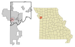
 Location of Oakwood, Missouri | |
| Coordinates: 39°12′02″N 94°34′14″W / 39.20056°N 94.57056°W | |
| Country | United States |
| State | Missouri |
| County | Clay |
| Area | |
• Total | 0.20 sq mi (0.51 km2) |
| • Land | 0.20 sq mi (0.51 km2) |
| • Water | 0.00 sq mi (0.00 km2) |
| Elevation | 997 ft (304 m) |
| Population (2020) | |
• Total | 198 |
| • Density | 1,005.08/sq mi (387.24/km2) |
| Time zone | UTC-6 (Central (CST)) |
| • Summer (DST) | UTC-5 (CDT) |
| ZIP code | 64118[3] |
| Area code(s) | 816 and 975 |
| FIPS code | 29-53894[4] |
| GNIS feature ID | 2399548[2] |
Oakwood is a village in Clay County, Missouri, United States. The population was 198 at the 2020 census.[5] It is part of the Kansas City metropolitan area.
Oakwood was laid out in the early 1920s, and named for a grove of oak trees near the original town site.[6]
- ^ "ArcGIS REST Services Directory". United States Census Bureau. Retrieved August 28, 2022.
- ^ a b U.S. Geological Survey Geographic Names Information System: Oakwood, Missouri
- ^ "Oakwood MO ZIP Code". zipdatamaps.com. 2024. Retrieved March 5, 2024.
- ^ "U.S. Census website". United States Census Bureau. Retrieved January 31, 2008.
- ^ "Explore Census Data". data.census.gov. Retrieved December 27, 2021.
- ^ "Clay County Place Names, 1928–1945 (archived)". The State Historical Society of Missouri. Archived from the original on June 24, 2016. Retrieved September 21, 2016.
{{cite web}}: CS1 maint: bot: original URL status unknown (link)
Previous Page Next Page


