Our website is made possible by displaying online advertisements to our visitors.
Please consider supporting us by disabling your ad blocker.

Oberwald
This article includes a list of references, related reading, or external links, but its sources remain unclear because it lacks inline citations. (December 2015) |
Oberwald | |
|---|---|
 | |
 Coat of arms | |
Location of Oberwald  | |
 Oberwald  Oberwald | |
| Coordinates: 46°32′N 8°21′E / 46.533°N 8.350°E | |
| Country | Switzerland |
| Canton | Valais |
| District | Goms |
| Municipality | Obergoms |
| Area | |
• Total | 96.9 km2 (37.4 sq mi) |
| Elevation | 1,377 m (4,518 ft) |
| Population (2007-12-31) | |
• Total | 277 |
| • Density | 2.9/km2 (7.4/sq mi) |
| Time zone | UTC+01:00 (Central European Time) |
| • Summer (DST) | UTC+02:00 (Central European Summer Time) |
| Postal code(s) | 3999 |
| SFOS number | 6066 |
| ISO 3166 code | CH-VS |
| Localities | Gletsch |
| Website | www |
Oberwald is a village in the municipality of Obergoms in Goms District in the canton of Valais in Switzerland.
It is situated at an elevation of 1,377 m and had a population of 277 in December 2007.[citation needed] It is located at the end of the Goms, directly before the Furka and Grimsel passes, underneath the Rhône River source at the Rhône Glacier. It is also the startpoint of the Furka Tunnel and is served by Oberwald railway station. Most inhabitants live off tourism or sheep farming.
Oberwald was an independent municipality until January 1, 2009, when it merged with Ulrichen and Obergesteln to form the municipality of Obergoms.
-
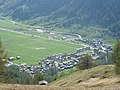 View of Oberwald from above
 -
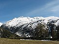 View of the mountains from Oberwald


Previous Page Next Page

