Our website is made possible by displaying online advertisements to our visitors.
Please consider supporting us by disabling your ad blocker.
Ogallala, Nebraska
Ogallala, Nebraska | |
|---|---|
 Front Street tourist attraction | |
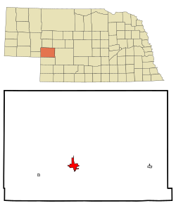
 Location of Ogallala, Nebraska | |
| Coordinates: 41°07′46″N 101°43′15″W / 41.12944°N 101.72083°W | |
| Country | United States |
| State | Nebraska |
| County | Keith |
| Founded | 1868 |
| Government | |
| • Type | City Council/City Manager |
| • Mayor | Deb Schilz |
| • City Manager | Bruce Smith |
| Area | |
• Total | 5.02 sq mi (13.00 km2) |
| • Land | 4.96 sq mi (12.84 km2) |
| • Water | 0.06 sq mi (0.16 km2) |
| Elevation | 3,232 ft (985 m) |
| Population (2020) | |
• Total | 4,878 |
| • Density | 984.06/sq mi (379.96/km2) |
| Time zone | UTC-7 (Mountain (MST)) |
| • Summer (DST) | UTC-6 (MDT) |
| ZIP code | 69153 |
| Area code | 308 |
| FIPS code | 31-35980 |
| GNIS feature ID | 2395305[2] |
| Website | ogallala-ne.gov |
Ogallala is a city in and the county seat of Keith County, Nebraska, United States.[3] The population was 4,878 at the 2020 census, up from 4,737 at the 2010 census. In the days of the Nebraska Territory, the city was a stop on the Pony Express and later along the transcontinental railroad. The Ogallala Formation that carries the Ogallala Aquifer was named after the city.
- ^ "ArcGIS REST Services Directory". United States Census Bureau. Retrieved September 18, 2022.
- ^ a b U.S. Geological Survey Geographic Names Information System: Ogallala, Nebraska
- ^ "Find a County". National Association of Counties. Archived from the original on May 31, 2011. Retrieved June 7, 2011.
Previous Page Next Page


