Our website is made possible by displaying online advertisements to our visitors.
Please consider supporting us by disabling your ad blocker.
Old Saybrook, Connecticut
Old Saybrook, Connecticut | |
|---|---|
| Town of Old Saybrook | |
 | |
| Coordinates: 41°17′38″N 72°22′57″W / 41.29389°N 72.38250°W | |
| Country | |
| U.S. state | |
| County | Middlesex |
| Region | Lower CT River Valley |
| Settled | 1738 |
| Incorporated | 1854 |
| Government | |
| • Type | Selectman-town meeting |
| • First selectman | Carl P. Fortuna, Jr. (R) |
| • Selectman | Scott Geigerich (R) |
| • Selectman | Matt Pugliese (D) |
| Area | |
• Total | 21.6 sq mi (55.9 km2) |
| • Land | 15.0 sq mi (38.8 km2) |
| • Water | 6.6 sq mi (17.0 km2) |
| Elevation | 20 ft (6 m) |
| Population (2020) | |
• Total | 10,481 |
| • Density | 700/sq mi (270.1/km2) |
| Time zone | UTC−5 (Eastern) |
| • Summer (DST) | UTC−4 (Eastern) |
| ZIP code | 06475 |
| Area code(s) | 860/959 |
| FIPS code | 09-57320 |
| GNIS feature ID | 0213484[1] |
| Website | www |
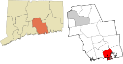
Old Saybrook is a town in Middlesex County, Connecticut, United States. The town is part of the Lower Connecticut River Valley Planning Region. The population was 10,481 at the 2020 census.[2] It contains the incorporated borough of Fenwick, and the census-designated places of Old Saybrook Center and Saybrook Manor.
Previous Page Next Page


