Our website is made possible by displaying online advertisements to our visitors.
Please consider supporting us by disabling your ad blocker.
Onizuka Air Force Station
| Onizuka Air Force Station | |
|---|---|
| Sunnyvale, California in U.S. | |
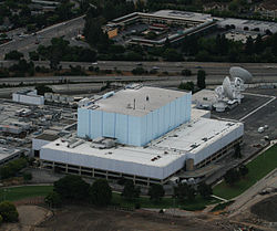
 Onizuka AFS in 2009 | |
 | |
| Coordinates | 37°24′17.5″N 122°1′43.5″W / 37.404861°N 122.028750°W |
| Type | U.S. Air Force station |
| Site information | |
| Owner | Department of Defense |
| Operator | U.S. Air Force |
| Controlled by | Air Force Space Command |
| Condition | Closed |
| Website | Official website (archived) |
| Site history | |
| Built | 1960 (as Sunnyvale AFS) |
| In use | 1960 – 30 September 2010 |
| Fate | Demolished (2014) |
Onizuka Air Force Station or Onizuka AFS was a U.S. Air Force installation in Sunnyvale, California, at the intersection of State Route 237 and North Mathilda Avenue.[1] It operated from 1960 to 2010.
One of its distinguishing feature was Building 1003, known locally as the Blue Cube and the "Cube" given its shape, color, and lack of windows. The station's other distinguishing features were its three primary parabolic dish antennas, used for communication with remote tracking stations used to control military satellites; these antennas were named Sun East, Sun West, and Sun 3.
- ^ "Onizuka Air Force Station Local Redevelopment Authority Redevelopment Plan (Draft)" (PDF). City of Sunnyvale. 19 November 2008. Retrieved 29 October 2020.
Previous Page Next Page


