Our website is made possible by displaying online advertisements to our visitors.
Please consider supporting us by disabling your ad blocker.
Ostrobothnia (region)
Ostrobothnia
| |
|---|---|
| Region of Ostrobothnia Landskapet Österbotten Pohjanmaan maakunta | |
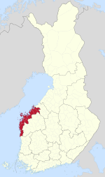
 Ostrobothnia on a map of Finland | |
| Country | Finland |
| Historical province | Ostrobothnia |
| Capital | Vaasa |
| Other towns | Jakobstad, Kaskinen, Kristinestad, Närpes and Nykarleby |
| Area | |
• Total | 7,932.36 km2 (3,062.70 sq mi) |
| Population (2019) | |
• Total | 180,445 |
| • Density | 23/km2 (59/sq mi) |
| GDP | |
| • Total | €6.929 billion (2015) |
| • Per capita | €38,193 (2015) |
| Time zone | UTC+2 (EET) |
| • Summer (DST) | UTC+3 (EEST) |
| ISO 3166 code | FI-12 |
| NUTS | 195 |
| Regional bird | Common swift (Apus apus) |
| Regional fish | Common whitefish (Coregonus lavaretus) |
| Regional flower | European meadowsweet (Filipendula ulmaria) |
| Website | osterbotten.fi |
Ostrobothnia (Swedish: Österbotten; Finnish: Pohjanmaa) is a region in western Finland. It borders the regions of Central Ostrobothnia, South Ostrobothnia, and Satakunta. It is one of six regions considered historical Ostrobothnia, hence it is also referred to as Coastal Ostrobothnia to avoid confusion.
Ostrobothnia is one of two Finnish regions with a Swedish-speaking majority (the other being the constitutionally monolingual province of Åland); Swedish-speakers make up 51.2% of the total population.[2] The region contains thirteen bilingual municipalities and one that is exclusively Finnish-speaking. The capital of Vaasa is predominantly inhabited by Finnish speakers, whereas smaller towns and rural areas are generally dominated by the Swedish language. The three municipalities with the largest number of Swedish speakers are Korsholm, Jakobstad and Pedersöre.
Geographically, Ostrobothnia has little topographical relief, because it is mostly former seafloor brought to surface by post-glacial rebound and the accumulation of alluvial sediment. Ostrobothnia has both vast expanses of cultivated fields (lakeus) as in Southern Ostrobothnia, and the archipelago of Kvarken (Finnish: Merenkurkku). Glacial transport has deposited large quantities of rocks in the area.[3] Like elsewhere in Ostrobothnia, rivers are a prominent part of the landscape. The major rivers that discharge into the Gulf of Bothnia in Ostrobothnia are Kyrönjoki, Lapuanjoki and Ähtävänjoki.
Kaskinen, a coastal town located in the southern part of the region, is the smallest town in Finland in terms of both area and population.[4]
- ^ Regions and Cities > Regional Statistics > Regional Economy > Regional GDP per Capita, OECD.Stats. Accessed on 16 November 2018.
- ^ Väestö iän ja sukupuolen mukaan alueittain[permanent dead link] 31.12.2008. Tilastokeskus: demography.
- ^ "Aika, kallioperä ja jääkaudet » Merenkurkun saaristo". www.merenkurkku.fi. Retrieved 15 April 2018.
- ^ "Island town | Visit Kaskinen". visitkaskinen.fi.
Previous Page Next Page


