Our website is made possible by displaying online advertisements to our visitors.
Please consider supporting us by disabling your ad blocker.
Outerbridge Crossing
Outerbridge Crossing | |
|---|---|
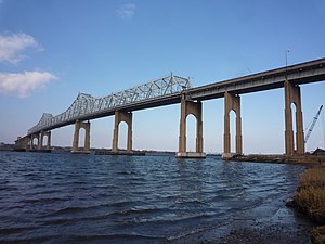
 Outerbridge Crossing looking northwest towards New Jersey. | |
| Coordinates | 40°31′30″N 74°14′49″W / 40.525°N 74.247°W |
| Carries | 4 lanes of |
| Crosses | Arthur Kill |
| Locale | Perth Amboy, New Jersey, and Staten Island, New York, U.S. |
| Maintained by | Port Authority of New York and New Jersey |
| Characteristics | |
| Design | Steel cantilever bridge |
| Total length | 8,800 feet (2,682 m)[1] |
| Width | 62 feet (18.9 m) |
| Longest span | 750 feet (229 m) |
| Clearance above | 14 feet (4.3 m) |
| Clearance below | 143 feet (43.6 m)[2] |
| History | |
| Opened | June 29, 1928 |
| Statistics | |
| Daily traffic | 77,107 (2016)[3] |
| Toll | (Eastbound only) As of January 7, 2024:
|
| Location | |
 | |
The Outerbridge Crossing, also known as the Outerbridge, is a cantilever bridge that spans the Arthur Kill between Perth Amboy, New Jersey, and Staten Island, New York, United States. It carries New York State Route 440 and New Jersey Route 440, with the two roads connecting at the state border at the river’s center. The Outerbridge Crossing is one of three vehicular bridges connecting New Jersey with Staten Island, and like the others, is maintained and operated by the Port Authority of New York and New Jersey. The others are the Bayonne Bridge (also carrying Route 440), which connects Staten Island with Bayonne, and the Goethals Bridge (carrying I-278), which connects the island with Elizabeth.
- ^ "Facts & Info - Outerbridge Crossing - The Port Authority of NY & NJ". www.panynj.gov. Retrieved February 22, 2023.
- ^ "Facts & Info - Outerbridge Crossing - The Port Authority of NY & NJ". www.panynj.gov. Retrieved January 19, 2014.
- ^ "New York City Bridge Traffic Volumes" (PDF). New York City Department of Transportation. 2016. p. 11. Retrieved March 16, 2018.
Previous Page Next Page


