Our website is made possible by displaying online advertisements to our visitors.
Please consider supporting us by disabling your ad blocker.
Palmarolle
Palmarolle | |
|---|---|
 Downtown Palmarolle | |
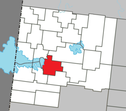
 Location within Abitibi-Ouest RCM | |
| Coordinates: 48°40′N 79°12′W / 48.667°N 79.200°W[1] | |
| Country | Canada |
| Province | Quebec |
| Region | Abitibi-Témiscamingue |
| RCM | Abitibi-Ouest |
| Settled | 1911 |
| Constituted | April 14, 1930 |
| Government | |
| • Mayor | Véronique Aubin |
| • Federal riding | Abitibi—Témiscamingue |
| • Prov. riding | Abitibi-Ouest |
| Area | |
• Total | 135.37 km2 (52.27 sq mi) |
| • Land | 117.87 km2 (45.51 sq mi) |
| Population (2021)[3] | |
• Total | 1,386 |
| • Density | 11.8/km2 (31/sq mi) |
| • Pop (2016-21) | |
| • Dwellings | 649 |
| Time zone | UTC−5 (EST) |
| • Summer (DST) | UTC−4 (EDT) |
| Postal code(s) | |
| Area code | 819 |
| Highways | |
| Website | palmarolle |
Palmarolle (French pronunciation: [palmaʁɔl]) is a municipality in northwestern Quebec, Canada, in the Abitibi-Ouest Regional County Municipality. It covers 117.87 km2 and had a population of 1,386 as of the Canada 2021 Census. It is considered to have the best agricultural land of the entire Abitibi region.[1]
- ^ a b "Palmarolle (Municipalité)" (in French). Commission de toponymie du Québec. Retrieved 2011-01-06.
- ^ a b "Palmarolle". Répertoire des municipalités (in French). Ministère des Affaires municipales et de l'Habitation. Retrieved 2023-07-10.
- ^ a b "Palmarolle (Code 2487025) Census Profile". 2021 census. Government of Canada - Statistics Canada.
Previous Page Next Page


