Our website is made possible by displaying online advertisements to our visitors.
Please consider supporting us by disabling your ad blocker.
Panay River
| Panay River | |
|---|---|
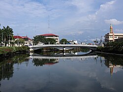
 Panay River in Roxas City | |
Panay River mouth | |
| Location | |
| Country | Philippines |
| Region | Western Visayas |
| Province | Capiz |
| City/municipality | |
| Physical characteristics | |
| Source | Central Panay Mountain Range |
| • location | Mount Angas, Tapaz, Capiz |
| Mouth | Sibuyan Sea |
• location | Roxas, Capiz |
• coordinates | 11°35′05″N 122°42′57″E / 11.5847°N 122.7158°E |
• elevation | 0 m (0 ft) |
| Length | 152 kilometres (94 mi)[1] |
| Basin size | 2,203.76 km2 (850.88 sq mi)[2] |
| Discharge | |
| • average | 119.75 m3/s (4,229 cu ft/s)[2] |
| Basin features | |
| Tributaries | |
| • left | [1] |
| • right | [1] |
 | |
The Panay River (known as Pan-ay River) is the longest river on Panay Island in the Philippines, with a total length of approximately 152 kilometres (94 mi)[1] and a drainage basin area of 2,203.76 square kilometres (850.88 sq mi).[2] It drains almost the entire province of Capiz and northern portion of Iloilo province.
The source of the Panay River is on the slopes of Mount Igabon–Mount Angas Mountain Range. Starting in Tapaz, it runs southward and changing its direction toward east-northeast to Dumalag and Cuartero, then traversing north through the municipalities of Dao and Panitan. In Panay the river splits, with the primary branch emptying into the Sibuyan Sea at Roxas City.[2]
- ^ a b c d "Capiz". Philippine Information Agency. Archived from the original on June 28, 2018. Retrieved March 1, 2019.
- ^ a b c d "Integrated River Basin Management and Development Master Plan Panay River Basin" (PDF). riverbasin.denr.gov.ph. Department of Environment and Natural Resources (DENR). November 2014. Retrieved March 5, 2021.
Previous Page Next Page


