Our website is made possible by displaying online advertisements to our visitors.
Please consider supporting us by disabling your ad blocker.
Paris metropolitan area
Paris metropolitan area
aire d'attraction de Paris | |
|---|---|
 Paris, the most populated city in the metropolitan area | |
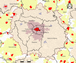
 Map showing the extent of the Paris metropolitan area as of 2020, when it included 1,929 communes and covered 18,941 km2.
Central commune
Primary urban cluster
Secondary urban cluster
Peripheral commune
Peripheral commune of a functional area with less than 200,000 inhabitants | |
| Country | |
| Largest city | Paris (2,165,423) |
| Area | |
| • Metro | 18,941 km2 (7,313 sq mi) |
| Population | |
| • Metro | 13,064,617 |
| • Metro density | 690/km2 (1,800/sq mi) |
| GDP | |
| • Metro | |
| Time zone | UTC+01:00 (CET) |
The Paris metropolitan area (French: aire d'attraction de Paris) is a statistical area that describes the reach of commuter movement to and from Paris, France and its surrounding suburbs.
- ^ "Gross domestic product (GDP) at current market prices by metropolitan region". ec.europa.eu/eurostat. Eurostat. 2024-02-28. Retrieved 2024-11-13.
Previous Page Next Page


