Our website is made possible by displaying online advertisements to our visitors.
Please consider supporting us by disabling your ad blocker.
Peace Arch
| Peace Arch | |
|---|---|
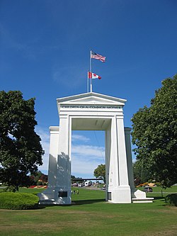
 The Peace Arch from the U.S. side. | |
| Location | Blaine, Washington, U.S. Surrey, British Columbia, Canada |
| Coordinates | 49°00′07.7″N 122°45′23.5″W / 49.002139°N 122.756528°W |
| Height | 67 feet (20 m) |
| Built | 1921 |
| Architect | Harvey Wiley Corbett |
| Architectural style(s) | Classical Revival |
| Governing body | Local |
| Designated | December 13, 1996 |
| Reference no. | 96001493 [1] |
The Peace Arch (French: Arche de la Paix) is a monument situated near the westernmost point of the Canada–United States border in the contiguous United States, between the communities of Blaine, Washington and Surrey, British Columbia. Construction of the 20.5-meter (67 ft) tall arch was headed by American lawyer Sam Hill and dedicated in September 1921. The Peace Arch commemorates the signing of the Treaty of Ghent in 1814, and symbolizes a long history of peace between the two nations. The monument is built on the exact U.S.–Canada boundary, where Interstate 5 on the U.S. side of the border becomes Highway 99 on the Canadian side, in the grass median between the northbound and southbound lanes.
The monument and the surrounding land is part of Peace Arch Park. Within the park is Peace Arch Border Crossing, a major border crossing between Interstate 5 and British Columbia Highway 99.
- ^ "National Register Information System". National Register of Historic Places. National Park Service. January 23, 2007.
Previous Page Next Page


