Our website is made possible by displaying online advertisements to our visitors.
Please consider supporting us by disabling your ad blocker.
Peberholm
 View of Peberholm and the Øresund Bridge (from the north west) | |
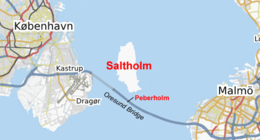
 Location of Peberholm, in the Øresund | |
| Geography | |
|---|---|
| Location | Øresund, Baltic Sea |
| Coordinates | 55°36′N 12°45′E / 55.600°N 12.750°E |
| Area | 1.3 km2 (0.50 sq mi) |
| Highest point | unnamed |
| Administration | |
Denmark | |
| Region | Hovedstaden |
| Municipality | Tårnby |
| Demographics | |
| Population | 0 (2020) |
| Pop. density | 0/km2 (0/sq mi) |
| Ethnic groups | none |
| [1] | |
Peberholm (Danish pronunciation: [ˈpʰe̝wɐˌhʌlˀm] lit. 'Pepper Islet', Swedish: Pepparholm (Swedish pronunciation: [ˈpɛ̂pːarˌhɔlm])) is a small artificial island in the Danish part of the Øresund strait, created as part of the Øresund Bridge connecting Denmark with Sweden. Peberholm lies approximately 1 km south of the larger natural island of Saltholm (Salt Islet) and was named to complement it. It has an area of 1.3 km2 (320 acres) and belongs to Denmark.
- ^ Örneberg, Bengt; Snogerup, Sven; Snogerup, Britt; Segerbäck, Lennart; Runeson, Leif; Porenius, Alf (2012). "The flora on the artificial island Peberholm – a field study in plant succession". Nordic Journal of Botany. 145 (1). Wiley-Blackwell: 1–32. ISSN 0107-055X. Archived from the original on 2024-05-31. Retrieved 2024-05-31.
Previous Page Next Page


