Our website is made possible by displaying online advertisements to our visitors.
Please consider supporting us by disabling your ad blocker.
Peninsular Malaysia

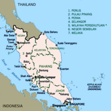
Peninsular Malaysia,[a] historically known as Malaya,[b] also known as West Malaysia or the "Malaysian Peninsula",[c] is the western part of Malaysia that comprises the southern part of the Malay Peninsula on Mainland Southeast Asia and the nearby islands.[1] Its area totals approximately 132,490 km2 (51,150 sq mi), which is nearly 40% of the total area of the country; the other 60% is in East Malaysia on the island of Borneo.
It shares a land border with Thailand to the north[2] and a maritime border with Singapore to the south. Across the Strait of Malacca to the west lies the island of Sumatra, and across the South China Sea to the east lie the Natuna Islands of Indonesia. At its southern tip, across the Strait of Johor, lies the island country of Singapore. Most of Peninsular Malaysia's interior is forested, mountainous and rural; the majority of Malaysia's population and economy are concentrated on the coastal western half, which is where the country's prominent urban areas are located.

Cite error: There are <ref group=lower-alpha> tags or {{efn}} templates on this page, but the references will not show without a {{reflist|group=lower-alpha}} template or {{notelist}} template (see the help page).
- ^ "Earth from Space: Separation by Sea". European Space Agency. 5 May 2006. Retrieved 15 July 2022.
- ^ "Peninsular Malaysia". Travelfish. Retrieved 15 July 2022.
Previous Page Next Page


