Our website is made possible by displaying online advertisements to our visitors.
Please consider supporting us by disabling your ad blocker.
Phra Nakhon district
Phra Nakhon
พระนคร | |
|---|---|
 | |
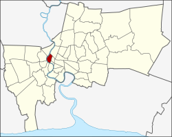
 District location in Bangkok | |
| Coordinates: 13°45′52″N 100°29′57″E / 13.76444°N 100.49917°E | |
| Country | Thailand |
| Province | Bangkok |
| Seat | Wat Sam Phraya |
| Khwaeng | 12 |
| Area | |
• Total | 5.536 km2 (2.137 sq mi) |
| Population (2017) | |
• Total | 51,231[1] |
| • Density | 9,254.15/km2 (23,968.1/sq mi) |
| Time zone | UTC+7 (ICT) |
| Postal code | 10200 |
| Geocode | 1001 |

Phra Nakhon (Thai: พระนคร, pronounced [pʰráʔ ná(ʔ).kʰɔ̄ːn]) is one of the 50 districts (khet) of Bangkok, Thailand. It is the central district of Bangkok, including Rattanakosin Island. Neighboring districts are, from the north, clockwise: Dusit, Pom Prap Sattru Phai, Samphanthawong, and across the Chao Phraya River, Thon Buri, Bangkok Yai, Bangkok Noi, and Bang Phlat.
- ^ "Population and House Report for Year 2017". Department of Provincial Administration, Ministry of Internal Affairs. Retrieved 2018-04-01. (Search page)
Previous Page Next Page


