Our website is made possible by displaying online advertisements to our visitors.
Please consider supporting us by disabling your ad blocker.
Phu Phan Mountains
| Phu Phan Mountains | |
|---|---|
| ทิวเขาภูพาน | |
 Phu Phan Mountains, view from Wat Tham Kham | |
| Highest point | |
| Peak | Phu Lang Ka |
| Elevation | 624 m (2,047 ft) |
| Coordinates | 16°46′22″N 104°21′45″E / 16.77278°N 104.36250°E |
| Dimensions | |
| Length | 180 km (110 mi) NW/SE |
| Width | 50 km (31 mi) NE/SW |
| Geography | |
| Country | Thailand |
| Region(s) | Nong Bua Lamphu Udon Thani Sakon Nakhon Nakhon Phanom Kalasin Roi Et Maha Sarakham Mukdahan |
| Geology | |
| Rock age | Early Cretaceous |
| Rock type(s) | Sandstone and siltstone |
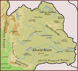
The Phu Phan mountains (Thai: ทิวเขาภูพาน, RTGS: Thio Khao Phu Phan, pronounced [tʰīw kʰǎw pʰūː pʰāːn]; Northeastern Thai: ทิวเขาภูพาน, pronounced [tʰîw kʰǎw pʰûː pʰâːn]) are a range of hills dividing the Khorat Plateau of the Isan region of Thailand into two basins: the northern Sakhon Nakhon Basin, and the southern Khorat Basin.[1]
The silhouette of the Phu Phan Mountains appears in the provincial seal of Kalasin since they form the northern boundary of the province.[2]
The Phu Phan mountains are among the places in Thailand more severely affected by the Illegal logging of Phayung (Siamese Rosewood) trees. Although officially a protected tree, the cutting and trading of the endangered rosewood trees has been going unabated in Thailand's mountainous forested zones, even in the protected areas. In Thailand and in China this wood is highly valued in the furniture industry.[3][4]
- ^ Schuler, Ulrich. "NE-Thailand (Isan)". Geosciences. Retrieved 23 July 2017.
- ^ Seals of The Provinces of Thailand
- ^ Fredrickson, Terry (2011-09-19). "Forest robbery". Bangkok Post. Retrieved 10 November 2015.
- ^ Waewkraihong, Jakkrit (6 Feb 2013). "Cambodians caught for phayung smuggling". Bangkok Post. Retrieved 10 November 2015.
Previous Page Next Page


