Our website is made possible by displaying online advertisements to our visitors.
Please consider supporting us by disabling your ad blocker.
Pocomoke River
| Pocomoke River | |
|---|---|
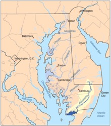
 Map of the rivers of the Eastern Shore of Maryland with the Pocomoke and its watershed highlighted. | |
| Location | |
| Country | United States |
| State | Delaware, Maryland, & Virginia |
| Region | Delmarva Peninsula |
| Physical characteristics | |
| Source | Great Cypress Swamp |
| Mouth | Pocomoke Sound |
• elevation | 0 ft (0 m) |
| Length | 66 mi (106 km), northeast-to-southwest |
| Basin features | |
| Tributaries | |
| • left | Dividing Creek, Nassawango Creek, Givens Branch, Aydelotte Branch |
| • right | Pitts Creek, Pilchard Creek, Mattaponi Creek, Corkers Creek |
The Pocomoke River stretches approximately 66 miles (106 km)[1] from southern Delaware through southeastern Maryland in the United States. At its mouth, the river is essentially an arm of Chesapeake Bay, whereas the upper river flows through a series of relatively inaccessible wetlands called the Great Cypress Swamp, largely populated by Loblolly Pine, Red Maple and Bald Cypress. The river is the easternmost river that flows into Chesapeake Bay. "Pocomoke" locally /ˈpoʊkoʊmoʊk/, though traditionally interpreted as "dark (or black) water" by local residents, is now agreed by scholars of the Algonquian languages to be derived from the words for "broken (or pierced) ground."[2]
- ^ U.S. Geological Survey. National Hydrography Dataset high-resolution flowline data. The National Map Archived 2012-03-29 at the Wayback Machine, accessed April 1, 2011
- ^ Nestor, Sandy (2004). Indian Placenames in America. McFarland. p. 80. ISBN 9780786493395. Archived from the original on 21 February 2017. Retrieved 20 February 2017.
Previous Page Next Page


