Our website is made possible by displaying online advertisements to our visitors.
Please consider supporting us by disabling your ad blocker.
Pungwe River
| Pungwe River | |
|---|---|
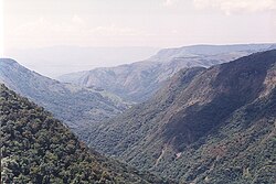
 Pungwe gorge in Nyanga National Park, Zimbabwe | |
 Map of the Pungwe River basin | |
| Native name | Rio Púngoè or Rio Púnguè (Portuguese) |
| Location | |
| Country | Zimbabwe and Mozambique |
| Physical characteristics | |
| Source | |
| • location | Mount Nyangani (Zimbabwe) |
| • elevation | 1,500 m (4,900 ft) |
| Mouth | |
• location | Beira, Indian Ocean |
• coordinates | 19°51′55″S 34°49′07″E / 19.865278°S 34.818611°E |
• elevation | 0 m (0 ft) |
| Length | 400 km (250 mi) |
| Basin size | 31,151 km2 (12,027 sq mi) to 32,243.7 km2 (12,449.4 sq mi)[1] |
| Discharge | |
| • average | (Period: 1979–2015) 20.44 km3/a (648 m3/s)[2] (Period: 1971–2000) 615.9 m3/s (21,750 cu ft/s)[1] 120 m3/s (4,200 cu ft/s)[3] to 133 m3/s (4,700 cu ft/s)[4] |
| Basin features | |
| River system | Pungwe River |
| Tributaries | |
| • left | Vunduzi, Urema |
| • right | Honde |
| Waterfalls | Pungwe Falls |
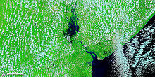
Pungwe River (Portuguese: Rio Púngoè or Rio Púnguè[5]) is a 400 km (250 mi) long river in Zimbabwe and Mozambique.[3][4] It rises below Mount Nyangani in the Eastern Highlands of Zimbabwe and then flows southeastwards through the Manica and Sofala provinces of Mozambique. The Pungwe enters the Urema Valley, the southernmost portion of the Great Rift Valley, where it forms the southern boundary of Gorongosa National Park. The Urema River joins it, and the river follows the rift valley southward. Large seasonal wetlands form around the Pungwe and Urema rivers in the rift valley section. It empties into the Mozambique Channel at Beira, forming a large estuary.[4] It is one of the major rivers of Mozambique and often causes floods.[3][4]


- ^ a b "Indian Ocean Coast".
- ^ "GEF TWAP - Transboundary Waters Assessment Programme — GEF TWAP".
- ^ a b c Cite error: The named reference
Andersson et al. 2011was invoked but never defined (see the help page). - ^ a b c d Cite error: The named reference
The Pungwe River Monographwas invoked but never defined (see the help page). - ^ Cite error: The named reference
NGIAwas invoked but never defined (see the help page).
Previous Page Next Page


