Our website is made possible by displaying online advertisements to our visitors.
Please consider supporting us by disabling your ad blocker.
Putatan, Muntinlupa
Putatan | |
|---|---|
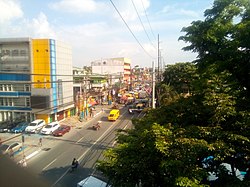
 Manila South Road at the vicinity of Medical Center Muntinlupa | |
 | |
| Coordinates: 14°23′54.12″N 121°2′10.96″E / 14.3983667°N 121.0363778°E | |
| Country | Philippines |
| Region | National Capital Region |
| City | Muntinlupa |
| District | 1st Legislative district of Muntinlupa |
| Government | |
| • Type | Barangay |
| • Barangay Captain | Gerardo Teves |
| • SK Chairperson | Cyrylle Kate Arciaga |
| Area | |
• Total | 6.746 km2 (2.605 sq mi) |
| Population (2020)[citation needed] | |
• Total | 99,725 |
| • Density | 15,000/km2 (38,000/sq mi) |
| Time zone | UTC+8 (PST) |
| Range | Marikina Valley Fault Ridge |
Putatan is a barangay in Muntinlupa, Metro Manila, Philippines. The total land area of the barangay is 6.746 km2 (2.605 sq mi). According to the 2020 census, it has a population of 99,725 as of 2020.
Putatan is located at the south of the City of Manila. It is bounded by barangays Alabang and Bayanan on the north, Laguna de Bay on the east, the Muntinlupa Poblacion on the south; and barangay Ayala Alabang on the west.
The barangay is also home to the city hall of Muntinlupa and its several departments.
Previous Page Next Page


