Our website is made possible by displaying online advertisements to our visitors.
Please consider supporting us by disabling your ad blocker.
Raby, Merseyside
| Raby | |
|---|---|
| Hamlet | |
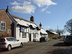
 The Wheatsheaf Inn, The Green, Raby | |
Location within Merseyside | |
| Population | 100 (2001 Census)[1] |
| OS grid reference | SJ309799 |
| • London | 175 mi (282 km)[2] SE |
| Metropolitan borough | |
| Metropolitan county | |
| Region | |
| Country | England |
| Sovereign state | United Kingdom |
| Post town | Wirral |
| Postcode district | CH63 |
| Dialling code | 0151 |
| ISO 3166 code | GB-WRL |
| Police | Merseyside |
| Fire | Merseyside |
| Ambulance | North West |
| UK Parliament | |
Raby (locally /ˈreɪbi/) is a hamlet in the Wirral district of Merseyside, England. It is on the Wirral Peninsula, in the Clatterbridge Ward. The settlement is within the parliamentary constituency of Wirral South. Raby is a former civil parish, but since 1974 has been directly administered by Wirral Council
Raby is close to Merseyside's boundary with Cheshire and is around 4 km (2.5 mi) North East of Neston and 5 km (3.1 mi) South West of Bebington. The hamlet of Raby Mere is 3.6 km (2.2 mi) to the east.
At the time of the United Kingdom Census 2001, Raby had a total population of 100.[1]
- ^ a b "Wirral 2001 Census: Raby". Metropolitan Borough of Wirral. Retrieved 21 February 2008. [dead link]
- ^ "Coordinate Distance Calculator". boulter.com. Retrieved 6 March 2016.
Previous Page Next Page


