Our website is made possible by displaying online advertisements to our visitors.
Please consider supporting us by disabling your ad blocker.
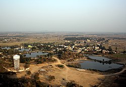
Raghunathpur, Purulia
Raghunathpur | |
|---|---|
Town | |
 | |
| Coordinates: 23°33′N 86°40′E / 23.55°N 86.67°E | |
| Country | |
| State | West Bengal |
| District | Purulia |
| Government | |
| • Type | Municipality |
| • Body | Raghunathpur Municipality |
| Area | |
• Total | 12.95 km2 (5.00 sq mi) |
| Elevation | 155 m (509 ft) |
| Population (2011) | |
• Total | 25,932 |
| • Density | 2,000/km2 (5,200/sq mi) |
| Languages | |
| • Official | Bengali, English |
| Time zone | UTC+5:30 (IST) |
| PIN | 723 133 |
| Telephone code | 91 3251 |
| Lok Sabha constituency | Bankura |
| Vidhan Sabha constituency | Raghunathpur, Para |
| Website | purulia |
Raghunathpur is a city and a municipality in Purulia district in the state of West Bengal, India. It is the headquarters of the Raghunathpur subdivision. Industrial City Raghunathpur is located near Adra on the North-East part of Purulia district. It is connected with other cities through five main way road's, which are Purulia – Barakar road, Raghunathpur-Adra-Hura road, Raghunathpur-Chas road, Cheliyama road and Raghunathpur-Bankura road. The nearest main junction stations are Joychandi Pahar railway station and Adra Junction railway station.
Previous Page Next Page


