Our website is made possible by displaying online advertisements to our visitors.
Please consider supporting us by disabling your ad blocker.
Ramallah and al-Bireh Governorate
Ramallah and al-Bireh Governorate | |
|---|---|
 | |
 | |
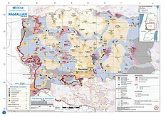
 2018 United Nations map of the area, showing the West Bank | |
| Coordinates: 31°55′59″N 35°12′18″E / 31.933°N 35.205°E | |
| Country | |
| Area | |
• Total | 844 km2 (326 sq mi) |
| Population (2017 Census)[1] | |
• Total | 328,861 |
| This figure excludes the Israeli West Bank Settlements | |
| ISO 3166 code | PS-RBH |
| Governorates of the West Bank (State of Palestine) |
|---|
The Ramallah and al-Bireh Governorate (Arabic: محافظة رام الله والبيرة Muḥāfaẓat Rām Allāh wa l Bīra) is one of 16 governorates of Palestine. It covers a large part of the central West Bank, on the northern border of the Jerusalem Governorate. Its district capital or muhfaza (seat) is the city of al-Bireh.[2][3]
According to the Palestinian Central Bureau of Statistics (PCBS), the district had a population of 279,730 in 2007.[4] Its governor is Dr Laila Ghannam, the first female governor.[5]
- ^ "Main Indicators by Type of Locality - Population, Housing and Establishments Census 2017" (PDF). Palestinian Central Bureau of Statistics (PCBS). Retrieved 2021-01-19.
- ^ :: Al-Bireh Municipality :: Archived 2008-06-20 at the Wayback Machine
- ^ Administrative divisions in Palestine Archived 2006-12-23 at the Wayback Machine
- ^ "Population, Housing and Establishment Census 2007" (PDF) (in Arabic and English). Palestinian National Authority, Palestinian Central Bureau of Statistics. Archived from the original (PDF) on 2010-11-14. Retrieved 2010-12-03.
- ^ "Ramallah Appoints First Female Governor - Just Don't Mess with Her - elan: The Guide to Global Muslim Culture". Archived from the original on 2010-12-16. Retrieved 2011-04-02.
Previous Page Next Page
محافظة رام الله والبيرة Arabic Gobernación de Ramala y Al Bireh AST রামাল্লা ও আল-বিরহ গভর্নোরেট Bengali/Bangla Governació de Ramal·lah i al-Bireh Catalan Llywodraethiaeth Ramallah ac Al-Bireh CY Gouvernement Ramallah und al-Bira German Gobernación de Ramala y Al Bireh Spanish Ramalla eta al-Birehko Gobernazioa EU استان رامالله و البیره FA Gouvernorat de Ramallah et Al-Bireh French


