Our website is made possible by displaying online advertisements to our visitors.
Please consider supporting us by disabling your ad blocker.
Raml Zayta
Raml Zayta
رمل زيتة Raml Zeita (Khirbat Qazaza) | |
|---|---|
Village | |
 | |
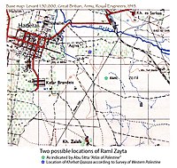
A series of historical maps of the area around Raml Zayta (click the buttons) | |
Location within Mandatory Palestine | |
| Coordinates: 32°25′42″N 34°58′17″E / 32.42830°N 34.97128°E | |
| Palestine grid | 145/203 |
| Geopolitical entity | Mandatory Palestine |
| Subdistrict | Tulkarm |
| Date of depopulation | 15 March 1948 |
| Population (1945) | |
• Total | 140[1] |
| Current Localities | Sde Yitzhak,[2] Chadera[2] |
Raml Zayta (Arabic: رمل زيتة, Raml Zeitâ), also Khirbet Qazaza, was a Palestinian Arab village located 15 km northwest of Tulkarm.[3]
Previous Page Next Page


