Our website is made possible by displaying online advertisements to our visitors.
Please consider supporting us by disabling your ad blocker.
Redan, Victoria
| Redan Ballarat, Victoria | |||||||||||||||
|---|---|---|---|---|---|---|---|---|---|---|---|---|---|---|---|
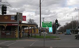
 Post office and commercial area on the junction of Skipton, Drummond and Darling Streets Redan | |||||||||||||||
 | |||||||||||||||
| Coordinates | 37°34′37″S 143°50′38″E / 37.577°S 143.844°E | ||||||||||||||
| Population | 3,000 (2021 census)[1] | ||||||||||||||
| • Density | 1,350/km2 (3,500/sq mi) | ||||||||||||||
| Postcode(s) | 3350 | ||||||||||||||
| Area | 2.23 km2 (0.9 sq mi) | ||||||||||||||
| Location | 3 km (2 mi) from Ballarat Central | ||||||||||||||
| LGA(s) | City of Ballarat | ||||||||||||||
| State electorate(s) | Wendouree | ||||||||||||||
| Federal division(s) | Ballarat | ||||||||||||||
| |||||||||||||||
Redan is an inner suburb of Ballarat, Victoria, Australia immediately south of Ballarat Central. The population at the 2021 census was 3,000.[1]
Its boundaries along Winter Street East, Pleasant Street, Sebastopol Street and Hill Street, on the north side; Yarrowee River forms the eastern boundary; Rubicon Street is the southern edge with Sutton Street forming the west side. Pleasant Street is the main road through the suburb and commercial area.
It was named for the fortifications used during the battle at Sevastopol during the Crimean War.[2]
- ^ a b Australian Bureau of Statistics (28 June 2022). "Redan (State Suburb)". 2021 Census QuickStats. Retrieved 3 November 2022.
- ^ "Sebastopol History Timeline". Archived from the original on 2 September 2010. Retrieved 14 September 2010.
Previous Page Next Page


