Our website is made possible by displaying online advertisements to our visitors.
Please consider supporting us by disabling your ad blocker.
Rio Grande del Norte National Monument
| Rio Grande del Norte National Monument | |
|---|---|
 Río Grande del Norte, New Mexico. | |
| Location | Taos County, New Mexico, United States |
| Nearest city | Questa, New Mexico |
| Coordinates | 36°40′0″N 105°42′0″W / 36.66667°N 105.70000°W |
| Area | 242,555 acres (98,159 ha)[1] |
| Established | March 25, 2013 |
| Governing body | U.S. Bureau of Land Management |
| Website | Rio Grande del Norte National Monument |

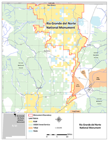
The Rio Grande del Norte National Monument is an approximately 242,555-acre (98,159 ha) area of public lands in Taos County, New Mexico, United States, proclaimed as a national monument on March 25, 2013, by President Barack Obama under the provisions of the Antiquities Act. It consists of the Rio Grande Gorge and surrounding lands, managed by the Bureau of Land Management (BLM).[2][3][4] [1]
The monument includes two BLM recreation areas, a portion of the Rio Grande designated as a Wild and Scenic River, and the Red River Wild and Scenic River.[4] On March 12, 2019, the John D. Dingell, Jr. Conservation, Management, and Recreation Act designated two federal wilderness areas within the monument: the Rio San Antonio Wilderness in the northwest corner, and the Cerro del Yuta Wilderness in the northeast corner.

- ^ a b "Presidential Proclamation -- Río Grande del Norte National Monument". whitehouse.gov. Retrieved 25 September 2017 – via National Archives.
- ^ Tom Sharpe (March 24, 2013). "Rio Grande del Norte National Monument may boost tourism". The Santa Fe New Mexican. Retrieved March 23, 2013.
- ^ John M. Broder (March 22, 2013). "Obama to Name New National Monuments" (blog "The Caucus"). The New York Times. Retrieved March 23, 2013.
- ^ a b "Rio Grande del Norte National Monument". Bureau of Land Management. Retrieved 26 March 2013.
Previous Page Next Page


