Our website is made possible by displaying online advertisements to our visitors.
Please consider supporting us by disabling your ad blocker.
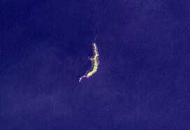
Ritter Island
| Ritter Island | |
|---|---|
 Ritter Island in 2004 | |
| Highest point | |
| Elevation | 140 m (460 ft) |
| Prominence | 140 m (460 ft) |
| Coordinates | 5°31′S 148°07′E / 5.517°S 148.117°E |
| Geography | |
 | |
| Location | Papua New Guinea |
| Geology | |
| Mountain type | Stratovolcano |
| Last eruption | May 2007 |
Ritter Island is a small crescent-shaped volcanic island 100 kilometres (62 mi) north-east of New Guinea, situated between Umboi Island and Sakar Island.
There are several recorded eruptions of this basaltic-andesitic stratovolcano prior to a spectacular lateral collapse which took place in 1888. Before that event, it was a circular conical island about 780 metres (2,560 ft) high.[1]
- ^ "Ritter Island". Global Volcanism Program. Smithsonian Institution. Retrieved 2009-04-28.
Previous Page Next Page


