Our website is made possible by displaying online advertisements to our visitors.
Please consider supporting us by disabling your ad blocker.
River Loughor
| River Loughor | |
|---|---|
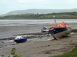
 River Loughor just above the Loughor bridges | |
| Native name | Afon Llwchwr |
| Location | |
| Country | Wales |
| Counties | Carmarthenshire Swansea |
| Physical characteristics | |
| Source | Black Mountain |
| • location | Llygad Llwchwr |
| Mouth | Carmarthen Bay |
• location | Loughor |
• coordinates | 51°40′N 4°05′W / 51.667°N 4.083°W |
The River Loughor (/ˈlʌxər/[1]) (Welsh: Afon Llwchwr) is a river in Wales which marks the border between Carmarthenshire and Swansea. The river is sourced from an underground lake at the Black Mountain emerging at the surface from Llygad Llwchwr which translates from the Welsh as "eye of the Loughor". It flows past Ammanford and Hendy in Carmarthenshire and Pontarddulais in Swansea. The river divides Carmarthenshire from Swansea for much of its course and it separates Hendy from Pontarddulais at the point where the river becomes tidal. The Loughor meets the sea at its estuary near the town of Loughor where it separates the south coast of Carmarthenshire from the north coast of the Gower Peninsula. Among its tributaries is the River Amman and the River Morlais, with the former joining the Loughor near Pantyffynnon. The area of the catchment is some 262 square kilometres (101 sq mi).[2]
In the 18th century, the river was a noted salmon and sea trout river. Fish from the river was then carried on ponies to be sold at Swansea Market. The fishing declined in the 19th century due to increasing pollution from industrialisation.
Carmarthenshire County Council is currently[when?] undertaking studies into the possibility of constructing a barrage across the River Loughor upstream from the Loughor bridges.[citation needed]
Previous Page Next Page


