Our website is made possible by displaying online advertisements to our visitors.
Please consider supporting us by disabling your ad blocker.
Robinson projection


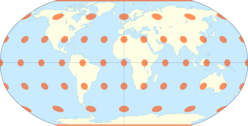
The Robinson projection is a map projection of a world map that shows the entire world at once. It was specifically created in an attempt to find a good compromise to the problem of readily showing the whole globe as a flat image.[1]
The Robinson projection was devised by Arthur H. Robinson in 1963 in response to an appeal from the Rand McNally company, which has used the projection in general-purpose world maps since that time. Robinson published details of the projection's construction in 1974. The National Geographic Society (NGS) began using the Robinson projection for general-purpose world maps in 1988, replacing the Van der Grinten projection.[2] In 1998, NGS abandoned the Robinson projection for that use in favor of the Winkel tripel projection, as the latter "reduces the distortion of land masses as they near the poles".[3][4]
- ^ John Noble Wilford (October 25, 1988). "The Impossible Quest for the Perfect Map". The New York Times. Retrieved 1 May 2012.
- ^ Snyder, John P. (1993). Flattening the Earth: 2000 Years of Map Projections. University of Chicago Press. p. 214. ISBN 0226767469.
- ^ "National Geographic Maps – Wall Maps – World Classic (Enlarged)". National Geographic Society. Retrieved 2019-02-17.
This map features the Winkel Tripel projection to reduce distortion of land masses as they near the poles.
- ^ "Selecting a Map Projection". National Geographic Society. Retrieved 2019-02-17.
Previous Page Next Page


