Our website is made possible by displaying online advertisements to our visitors.
Please consider supporting us by disabling your ad blocker.
Rose Bud, Arkansas
Rose Bud, Arkansas | |
|---|---|
 | |
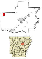
 Location of Rose Bud in White County, Arkansas. | |
| Coordinates: 35°19′30″N 92°04′52″W / 35.32500°N 92.08111°W | |
| Country | United States |
| State | Arkansas |
| County | White |
| Area | |
• Total | 6.07 sq mi (15.71 km2) |
| • Land | 6.04 sq mi (15.64 km2) |
| • Water | 0.03 sq mi (0.07 km2) |
| Elevation | 745 ft (227 m) |
| Population (2020) | |
• Total | 494 |
| • Density | 81.80/sq mi (31.59/km2) |
| Time zone | UTC-6 (Central (CST)) |
| • Summer (DST) | UTC-5 (CDT) |
| ZIP code | 72137 |
| Area code | 501 |
| FIPS code | 05-60770 |
| GNIS feature ID | 2407243[2] |
Rose Bud is a town in White County, Arkansas, in the United States. Rose Bud even with its small population is the fourth largest town in White County by area behind Beebe and Searcy. The demographics for the area are a majority Caucasian, then Hispanic being the second largest, followed by African-American, and Asian. A majority of the population by a small margin is between the age of 45 and 64.[3] Rose Bud also has their own school district with Pre-K through 12th grade.
- ^ "2020 U.S. Gazetteer Files". United States Census Bureau. Retrieved October 29, 2021.
- ^ a b U.S. Geological Survey Geographic Names Information System: Rose Bud, Arkansas
- ^ suburbanstats.org. "Current Rose Bud, Arkansas Population, Demographics and stats in 2020, 2019". SuburbanStats.org. Retrieved April 5, 2020.
Previous Page Next Page


