Our website is made possible by displaying online advertisements to our visitors.
Please consider supporting us by disabling your ad blocker.
Roya (river)
| Roya Roia, Roja | |
|---|---|
 The river at Ventimiglia | |
 | |
| Location | |
| Countries | France and Italy |
| Physical characteristics | |
| Source | |
| • location | Colle di Tenda near Tende, France. |
| • elevation | 1,908 m (6,260 ft) |
| Mouth | |
• location | Ligurian Sea at Ventimiglia, Italy |
• coordinates | 43°47′17″N 7°36′22″E / 43.78806°N 7.60611°E |
• elevation | 0 m (0 ft) |
| Length | 59 km (37 mi) |
| Basin size | 660 km2 (250 sq mi) |
| Discharge | |
| • average | 15 m3/s (530 cu ft/s) |
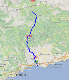
The Roya (French, [ʁwaja]), Roia (Italian), or Ròia (Brigasc, Occitan) is a river of France and Italy, discharging into the Ligurian Sea. It is 59 km (37 mi) long, of which 40.1 km (24.9 mi) in France.[1] Its drainage basin is about 660 km2 (250 sq mi), of which 601 km2 (232 sq mi) in France.[2]

- ^ Sandre. "Fiche cours d'eau - La Roya (Y66-0400)".
- ^ Bassin versant : Roya (La), Observatoire Régional Eau et Milieux Aquatiques en PACA
Previous Page Next Page


