Our website is made possible by displaying online advertisements to our visitors.
Please consider supporting us by disabling your ad blocker.
Saint-Charles-Garnier, Quebec
Saint-Charles-Garnier | |
|---|---|
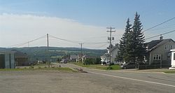
 Downtown Saint-Charles-Garnier | |
 Location within La Mitis RCM | |
| Coordinates: 48°20′N 68°03′W / 48.333°N 68.050°W[1] | |
| Country | |
| Province | |
| Region | Bas-Saint-Laurent |
| RCM | La Mitis |
| Constituted | January 1, 1966 |
| Named for | Charles Garnier[1] |
| Government | |
| • Mayor | Jean-Pierre Bélanger |
| • Federal riding | Haute-Gaspésie—La Mitis—Matane—Matapédia |
| • Prov. riding | Matane-Matapédia |
| Area | |
• Total | 84.80 km2 (32.74 sq mi) |
| • Land | 84.79 km2 (32.74 sq mi) |
| Population | |
• Total | 222 |
| • Density | 2.6/km2 (7/sq mi) |
| • Pop 2016-2021 | |
| • Dwellings | 151 |
| Time zone | UTC−5 (EST) |
| • Summer (DST) | UTC−4 (EDT) |
| Postal code(s) | |
| Area code(s) | 418 and 581 |
| Highways | |
| Website | www.municipalite. saint-charles-garnier.qc.ca |
Saint-Charles-Garnier (French pronunciation: [sɛ̃ ʃaʁl ɡaʁnje]) is a parish municipality in Quebec, Canada.
Previous Page Next Page


