Our website is made possible by displaying online advertisements to our visitors.
Please consider supporting us by disabling your ad blocker.
Salyan District, Nepal
Salyan District
सल्यान जिल्ला | |
|---|---|
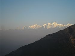
 View of the Himalayas from Chhayachhetra | |
 Location of Salyan District (dark yellow) in Karnali | |
| Country | |
| Admin HQ. | Salyan (today part of Shaarda Municipality) |
| Government | |
| • Type | Coordination committee |
| • Body | DCC, Salyan |
| Area | |
• Total | 1,462 km2 (564 sq mi) |
| Population (2011[1]) | |
• Total | 241,716 |
| • Density | 170/km2 (430/sq mi) |
| Time zone | UTC+05:45 (NPT) |
| Main Language(s) | Nepali,english,newari |
| Website | ddcsalyan |
Salyan District (Nepali: सल्यान जिल्लाⓘ) IPA: [sʌljan], in Karnali Province, is one of the seventy-seven districts of Nepal. Salyan covers an area of 1,462 km2 (564 sq mi) with a population of 213,500 in 2001 and 241,716 in 2011. The district's administrative center is named Salyan or Salyan Khalanga, today it is part of Shaarada Municipality.
The district is known for its Hindu temples including Shiva temples in Chhayachhetra and Laxmipur, and the Devi temple at Khairabang in Shaarada municipality, one of nine in Nepal.
- ^ Central Bureau of Statistics, Kathmandu, Nepal, Jan. 2014
Previous Page Next Page


