Our website is made possible by displaying online advertisements to our visitors.
Please consider supporting us by disabling your ad blocker.
Saquarema
This article needs additional citations for verification. (November 2013) |
Saquarema | |
|---|---|
| Municipality of Saquarema | |
| Nickname: Capital Nacional do Surfing | |
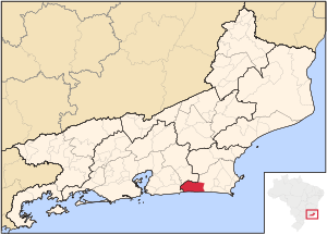
 Location in Rio de Janeiro | |
| Coordinates: 22°55′12″S 42°30′36″W / 22.92000°S 42.51000°W | |
| Country | |
| Region | Southeast |
| State | |
| Government | |
| • Mayor | Manoela Peres (UNIÃO) |
| Area | |
• Total | 357 km2 (138 sq mi) |
| Elevation | 2 m (7 ft) |
| Population (2020)[1] | |
• Total | 90,583 |
| • Density | 250/km2 (660/sq mi) |
| Time zone | UTC−3 (BRT) |
| HDI (2010) | 0.709 – high[2] |
| Website | saquarema |
Saquarema (Portuguese pronunciation: [sɐkwɐˈɾẽmɐ]) is a municipality located in the Brazilian state of Rio de Janeiro. Its population is 90,583 (2020) and its area is 357 km2.[3] It is located almost 73 km east of Rio de Janeiro.[4] It was known as Brazil's surfing capital.
During the mid-19th century, the Conservative Party and its leaders were known as "Saquarema" because of their base of support here.
- ^ IBGE 2020
- ^ "Archived copy" (PDF). United Nations Development Programme (UNDP). Archived from the original (PDF) on July 8, 2014. Retrieved August 1, 2013.
{{cite web}}: CS1 maint: archived copy as title (link) - ^ IBGE - [1]
- ^ Danny Palmerlee, South America on a Shoestring (Lonely Planet, 2007: ISBN 1-74104-443-X ), p. 300.
Previous Page Next Page


