Our website is made possible by displaying online advertisements to our visitors.
Please consider supporting us by disabling your ad blocker.
Sarthe
Sarthe | |
|---|---|
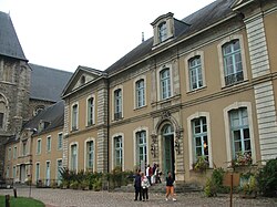
 Prefecture building of the Sarthe department, in Le Mans | |
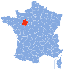
 Location of Sarthe in France | |
| Coordinates: 48°17′N 0°13′E / 48.283°N 0.217°E | |
| Country | France |
| Region | Pays de la Loire |
| Prefecture | Le Mans |
| Subprefectures | La Flèche Mamers |
| Government | |
| • President of the Departmental Council | Dominique Le Mèner[1] |
| Area | |
• Total | 6,206 km2 (2,396 sq mi) |
| Population (2022)[2] | |
• Total | 566,129 |
| • Rank | 46th |
| • Density | 91/km2 (240/sq mi) |
| Time zone | UTC+1 (CET) |
| • Summer (DST) | UTC+2 (CEST) |
| Department number | 72 |
| Arrondissements | 3 |
| Cantons | 21 |
| Communes | 354 |
| ^1 French Land Register data, which exclude estuaries, and lakes, ponds, and glaciers larger than 1 km2 | |

Sarthe (French pronunciation: [saʁt] ⓘ) is a department of the French region of Pays de la Loire, and the province of Maine, situated in the Grand-Ouest of the country. It is named after the river Sarthe, which flows from east of Le Mans to just north of Angers. It had a population of 566,412 in 2019.[3]
- ^ "Répertoire national des élus: les conseillers départementaux". data.gouv.fr, Plateforme ouverte des données publiques françaises (in French). 4 May 2022.
- ^ "Populations de référence 2022" (in French). The National Institute of Statistics and Economic Studies. 19 December 2024.
- ^ Populations légales 2019: 72 Sarthe, INSEE
Previous Page Next Page


