Our website is made possible by displaying online advertisements to our visitors.
Please consider supporting us by disabling your ad blocker.
Sawtooth National Forest
| Sawtooth National Forest | |
|---|---|
 | |
| Location | Blaine, Boise, Camas, Cassia, Custer, Elmore, Oneida, Power, and Twin Falls counties, Idaho, and Box Elder County, Utah, United States[1] |
| Nearest city | Twin Falls, ID |
| Coordinates | 43°44′N 114°40′W / 43.733°N 114.667°W |
| Area | 2,110,408 acres (8,540.52 km2) (administered); 1,802,133 acres (7,292.97 km2) (proclaimed)[2][3][4] |
| Established | May 29, 1905 |
| Visitors | 1,188,600 (in 2005)[5] |
| Governing body | U.S. Forest Service |
| Website | Sawtooth National Forest |
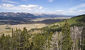
Sawtooth National Forest is a National Forest that covers 2,110,408 acres (854,052 ha) in the U.S. states of Idaho (~96 percent) and Utah (~4 percent). Managed by the U.S. Forest Service in the U.S. Department of Agriculture, it was originally named the Sawtooth Forest Reserve in a proclamation issued by President Theodore Roosevelt on May 29, 1905. On August 22, 1972, a portion of the forest was designated as the Sawtooth National Recreation Area (SNRA), which includes the Sawtooth, Cecil D. Andrus–White Clouds, and Hemingway–Boulders wilderness areas. The forest is managed as four units: the SNRA and the Fairfield, Ketchum, and Minidoka Ranger Districts.
Sawtooth National Forest is named for the Sawtooth Mountains, which traverse part of the SNRA. The forest also contains the Albion, Black Pine, Boise, Boulder, Pioneer, Raft River, Smoky, Soldier, Sublett, and White Cloud mountain ranges, as well as Hyndman Peak, the ninth-highest point in Idaho at 12,009 feet (3,660 m) above sea level. Sawtooth National Forest contains land cover types which include sagebrush steppe, spruce-fir forests, alpine tundra, and over 1,100 lakes and 3,500 miles (5,600 km) of rivers and streams. Plants and animals found only in the Sawtooth National Forest and adjacent lands include Christ's Indian paintbrush, Davis' springparsley, the South Hills crossbill, and the Wood River sculpin.
The area that is now Sawtooth National Forest was first occupied by people as early as 8000 BC and by the Shoshone tribe after 1700 AD. The first European descendants migrating from the eastern United States arrived in the area around the 1820s; they were mainly explorers, trappers, and prospectors, and they founded many of the current towns around what later became the forest. Sawtooth National Forest offers facilities for recreation, with four ski areas, whitewater and flatwater boating, hunting, 81 campgrounds, and over 1,000 mi (1,600 km) of trails and roads for hiking, mountain biking, and all-terrain vehicle use, including two National Recreation Trails.[3]
- ^ Cite error: The named reference
mapwas invoked but never defined (see the help page). - ^ Cite error: The named reference
VisitorGuidewas invoked but never defined (see the help page). - ^ a b Cite error: The named reference
SawtoothNFwas invoked but never defined (see the help page). - ^ Land Areas of the National Forest System (PDF). U.S. Forest Service. November 2015. Archived from the original (PDF) on January 25, 2016. Retrieved January 16, 2016.
- ^ "National Visitor Use Monitoring Results for Sawtooth National Forest". U.S. Forest Service. September 2006. Archived from the original on October 16, 2013. Retrieved June 12, 2012.
Previous Page Next Page


