Our website is made possible by displaying online advertisements to our visitors.
Please consider supporting us by disabling your ad blocker.
Scarborough Centre (provincial electoral district)
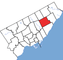
 Scarborough Centre in relation to the other Toronto ridings | |||
| Coordinates: | 43°45′11″N 79°16′23″W / 43.753°N 79.273°W | ||
| Provincial electoral district | |||
| Legislature | Legislative Assembly of Ontario | ||
| MPP |
Progressive Conservative | ||
| District created | 1963 | ||
| First contested | 1963 | ||
| Last contested | 2022 | ||
| Demographics | |||
| Population (2016) | 112,600 | ||
| Electors (2018) | 75,493 | ||
| Area (km²) | 28 | ||
| Pop. density (per km²) | 4,021.4 | ||
| Census division(s) | Toronto | ||
| Census subdivision(s) | Toronto | ||


Scarborough Centre is a provincial electoral district in Ontario, Canada, that has been represented in Legislative Assembly of Ontario since 1963.
It consists of the part of the Scarborough district of the City of Toronto bounded:
- on the west by Victoria Park Avenue,
- on the north by Highway 401,
- on the east by McCowan Road, Lawrence Avenue East and Bellamy Road North, and
- on the south by Eglinton Avenue East.
Notable landmarks in Scarborough Centre include:
- Scarborough Civic Centre, site of east Toronto district council meetings, and adjacent Albert Campbell Square
- Scarborough Town Centre, a large shopping mall
- Scarborough Centre (TTC) Line 3 station
- Scarborough and Rouge Hospital, General Division
- Scarborough Museum
It was represented in the Ontario Legislature by PC Christina Mitas since 2018, who did not run for re-election in 2022.
Scarborough Centre is a bellwether riding, having voted for the winner in every election since 1971 (longer than any other provincial riding). However, it did comprise different territories, changing shape significantly between the 1995 and 1999 elections.
Previous Page Next Page


