Our website is made possible by displaying online advertisements to our visitors.
Please consider supporting us by disabling your ad blocker.
Schouten Island
Schouten's Isle | |
|---|---|
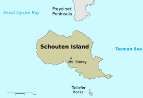
 Map of Schouten Island | |
Location of Schouten Island in Tasmania | |
| Etymology | In honour of Joost Schouten, a member of the Council of the Dutch East India Company; named in 1642 by Abel Tasman. |
| Geography | |
| Location | East coast of Tasmania |
| Coordinates | 42°18′36″S 148°16′12″E / 42.31000°S 148.27000°E[1] |
| Archipelago | Schouten Island Group |
| Adjacent to | Tasman Sea |
| Area | 28 km2 (11 sq mi) |
| Highest elevation | 400 m (1300 ft) |
| Highest point | Mount Storey |
| Administration | |
Australia | |
| State | Tasmania |
| Local government area | Glamorgan Spring Bay Council |
| Additional information | |
| Time zone | |
| • Summer (DST) | |
| Freycinet National Park | |
Schouten Island (formerly Schouten's Isle[2]), part of the Schouten Island Group, is an island with an area of approximately 28 square kilometres (11 sq mi) lying close to the eastern coast of Tasmania, Australia, located 1.6 kilometres (0.99 mi) south of the Freycinet Peninsula[3] and is a part of Freycinet National Park. The palawa kani place name for the island is mayaluwarana.[4]
The locality of Schouten Island is in the local government area of Glamorgan–Spring Bay in the South-east region of Tasmania.[5]
- ^ "Schouten Island, Tasmania (Islands & Reefs)". Gazetteer of Australia online. Geoscience Australia, Australian Government. Retrieved 29 December 2009.
- ^ "Chart of Van Dieman's Land. Map T358" (Map). Digital Maps Collection. National Library of Australia. 1826. Retrieved 12 August 2015.
- ^ Bacon, C. A; Corbett, K. D (10 August 1984). "The Schouten Island Coalfield" (PDF). Mineral Resources Tasmania, Department of Infrastructure, Energy and Resources. Tasmanian Government. Retrieved 29 December 2009.
- ^ "palawa kani place names map". Tasmanian Aboriginal Centre.
- ^ "Placenames Tasmania – Schouten Island". Placenames Tasmania. Select “Search”, enter "43790C", click “Search”, select row, map is displayed, click “Details”. Retrieved 4 August 2020.
Previous Page Next Page


