Our website is made possible by displaying online advertisements to our visitors.
Please consider supporting us by disabling your ad blocker.
Sembabule District
Sembabule District | |
|---|---|
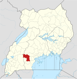
 District location in Uganda | |
| Coordinates: 00°06′S 31°30′E / 0.100°S 31.500°E | |
| Country | |
| Region | Buganda |
| Capital | Sembabule |
| Area | |
• Total | 2,470.5 km2 (953.9 sq mi) |
| • Land | 2,318.4 km2 (895.1 sq mi) |
| • Water | 152.1 km2 (58.7 sq mi) |
| Elevation | 1,200 m (3,900 ft) |
| Population (2012 Estimate) | |
• Total | 219,600 |
| • Density | 94.7/km2 (245/sq mi) |
| Time zone | UTC+3 (EAT) |
| Website | www |
Sembabule District is a district in the Central Region of Uganda. The town of Sembabule is the site of the district headquarters. Other urban centers in the district include Lwemiyaga and Ntuusi.[1]
- ^ "Map of Sembabule District, Central Region, Uganda" (Map). Google Maps. Retrieved 3 August 2016.
Previous Page Next Page


