Our website is made possible by displaying online advertisements to our visitors.
Please consider supporting us by disabling your ad blocker.
Seminole County, Oklahoma
Seminole County | |
|---|---|
 Seminole County Courthouse in Wewoka | |
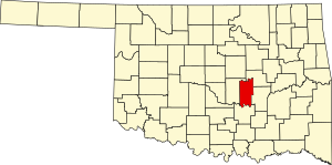
 Location within the U.S. state of Oklahoma | |
 Oklahoma's location within the U.S. | |
| Coordinates: 35°10′N 96°37′W / 35.17°N 96.61°W | |
| Country | |
| State | |
| Founded | 1907 |
| Seat | Wewoka |
| Largest city | Seminole |
| Area | |
• Total | 640 sq mi (1,700 km2) |
| • Land | 633 sq mi (1,640 km2) |
| • Water | 7.6 sq mi (20 km2) 1.2% |
| Population (2020) | |
• Total | 23,556 |
| • Density | 37/sq mi (14/km2) |
| Congressional district | 5th |
| Website | seminolecountyok |
Seminole County is a county located in the U.S. state of Oklahoma. As of the 2020 census, the population was 23,556.[1] Its county seat is Wewoka.[2] Most of the county was a reservation for the Seminole Nation of Oklahoma which still retains jurisdiction over some land in the county. A small portion of land at the eastern end of the county belonged to the Muscogee (Creek) Nation.
Seminole County is notable for the Greater Seminole Field, one of the most important oil fields ever found, which is still producing.[3] It extends into nearby counties. In the early years of the oil boom, workers and adventurers flooded into the county, rapidly tripling the population. As oil production later declined, jobs and residents left.
- ^ "Seminole County, Oklahoma". United States Census Bureau. Retrieved May 21, 2023.
- ^ "Find a County". National Association of Counties. Retrieved June 7, 2011.
- ^ Bobby D. Weaver, "Greater Seminole Field," Encyclopedia of Oklahoma History and Culture, Oklahoma Historical Society, 2009. Accessed April 5, 2015.
Previous Page Next Page
مقاطعة سيمينول (أوكلاهوما) Arabic سيمينول كاونتى، اوكلاهوما ARZ Seminole County, Oklahoma BAR Семинол (окръг, Оклахома) Bulgarian সেমিনোল কাউন্টি, ওকলাহোমা BPY Seminole Gông (Oklahoma) CDO Seminole County (kondado sa Tinipong Bansa, Oklahoma) CEB Seminole County, Oklahoma CY Seminole County (Oklahoma) German Condado de Seminole (Oklahoma) Spanish


