Our website is made possible by displaying online advertisements to our visitors.
Please consider supporting us by disabling your ad blocker.
Sha'ar HaNegev Regional Council
Sha'ar HaNegev Regional Council
מועצה אזורית שער הנגב مجلس إقليمي شاعر النقب | |
|---|---|
Regional council (from 1950) | |
 View on Highway 25 in 1998 | |
 | |
| Coordinates: 31°29′N 34°36′E / 31.483°N 34.600°E | |
| District | Southern |
| Government | |
| • Head of Municipality | Yossi Keren (acting) |
| Area | |
• Total | 180,780 dunams (180.78 km2 or 69.80 sq mi) |
| Population (2014) | |
• Total | 7,200 |
| • Density | 40/km2 (100/sq mi) |
| Website | Official website |
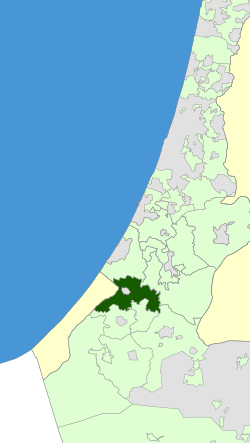
The Sha'ar HaNegev Regional Council (Hebrew: מועצה אזורית שער הנגב, Mo'atza Azorit Sha'ar HaNegev, lit. Gate of the Negev Regional Council), is a regional council in the north-western Negev, in Israel's Southern District. The Regional Council's territory lies midway between Beersheba and Ashkelon, bounded on the west by the Gaza Strip. The eastern border abuts Bnei Shimon. The city of Sderot forms an enclave within Sha'ar HaNegev.
The region's population is over 6,000, and covers an area of over 45,000 acres (approx. 180 km2 or 70 sq. mi.).[1] The average elevation is approximately 180 m (495 ft.) above sea level.
Sha'ar HaNegev Regional Council is in a sister city relationship with San Diego, California, in the United States of America,[2] and has a close working relationship with the Jewish Federation of San Diego County.[3]
- ^ Regional Council's website Archived 2008-04-08 at the Wayback Machine accessed Dec. 3, 2006
- ^ "San Diego Jewish Federation - Sha'ar HaNegev: San Diego's Sister City". jewishinsandiego.org. Archived from the original on 2015-06-30.
- ^ "Federation Support in Sha'ar HaNegev". Jewish Federation of San Diego County. Retrieved 1 August 2022.
Previous Page Next Page


