Our website is made possible by displaying online advertisements to our visitors.
Please consider supporting us by disabling your ad blocker.
Sha Tin
Sha Tin
沙田 | |
|---|---|
Neighbourhood | |
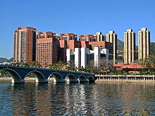
 Shing Mun River Promenade | |
| Coordinates: 22°22′30″N 114°11′00″E / 22.37500°N 114.18333°E | |
| Country | China |
| SAR | Hong Kong |
| District | Sha Tin District |
| Time zone | UTC+8 (HKT) |
| Sha Tin | |||||||||||||||
|---|---|---|---|---|---|---|---|---|---|---|---|---|---|---|---|
 | |||||||||||||||
| Chinese | 沙田 | ||||||||||||||
| Jyutping | Saa1 Tin4 | ||||||||||||||
| Literal meaning | sandy field | ||||||||||||||
| |||||||||||||||
Sha Tin, also spelt Shatin, is a neighbourhood along Shing Mun River in the eastern New Territories, Hong Kong. Administratively, it is part of the Sha Tin District. Sha Tin is one of the neighbourhoods of the Sha Tin New Town project.
The new town was founded in 1973 under the New Towns Development Programme of the Hong Kong government. Its current name was named after the nearby village of Sha Tin Wai. The literal English translation is 'Sand Fields'.
Previous Page Next Page


