Our website is made possible by displaying online advertisements to our visitors.
Please consider supporting us by disabling your ad blocker.
Shire of Kulin
| Shire of Kulin Western Australia | |||||||||||||||
|---|---|---|---|---|---|---|---|---|---|---|---|---|---|---|---|
 Kulin shire offices, 2014 | |||||||||||||||
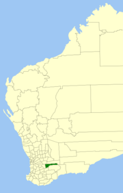
 Location in Western Australia | |||||||||||||||
 | |||||||||||||||
| Population | 769 (LGA 2021)[1] | ||||||||||||||
| Established | 1918 | ||||||||||||||
| Area | 4,713.7 km2 (1,820.0 sq mi) | ||||||||||||||
| Shire President | Barry West | ||||||||||||||
| Council seat | Kulin | ||||||||||||||
| Region | Wheatbelt | ||||||||||||||
| State electorate(s) | Central Wheatbelt | ||||||||||||||
| Federal division(s) | O'Connor | ||||||||||||||
 | |||||||||||||||
| Website | Shire of Kulin | ||||||||||||||
| |||||||||||||||
The Shire of Kulin is a local government area in the eastern Wheatbelt region of Western Australia, about 300 kilometres (186 mi) ESE of the state capital, Perth. The Shire's land area of 4,714 square kilometres (1,820 sq mi) forms a narrow east-west band, located between the Shire of Kondinin to the north and the Shire of Lake Grace to the south. Its seat of government is the town of Kulin. The local economy is based on agriculture - predominantly cereal grains and sheep.
- ^ Australian Bureau of Statistics (28 June 2022). "Kulin (Local Government Area)". Australian Census 2021 QuickStats. Retrieved 28 June 2022.
Previous Page Next Page


