Our website is made possible by displaying online advertisements to our visitors.
Please consider supporting us by disabling your ad blocker.
Shire of Murrindindi
| Shire of Murrindindi Victoria | |||||||||||||||
|---|---|---|---|---|---|---|---|---|---|---|---|---|---|---|---|
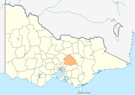
 Location in Victoria | |||||||||||||||
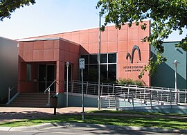
 Council Offices in Alexandra | |||||||||||||||
| Population | 15,197 (2021 census)[1] | ||||||||||||||
| • Density | 3.917/km2 (10.144/sq mi) | ||||||||||||||
| Established | 1994 | ||||||||||||||
| Gazetted | 18 November 1994[2] | ||||||||||||||
| Area | 3,880 km2 (1,498.1 sq mi)[3] | ||||||||||||||
| Mayor | Sandice McAulay | ||||||||||||||
| Council seat | Alexandra | ||||||||||||||
| Region | Hume | ||||||||||||||
| State electorate(s) | Eildon | ||||||||||||||
| Federal division(s) | Indi | ||||||||||||||
 | |||||||||||||||
| Website | Shire of Murrindindi | ||||||||||||||
| |||||||||||||||
The Shire of Murrindindi is a local government area in the Hume region of Victoria, Australia, located in the north-east part of the state. It covers an area of 3,880 square kilometres (1,500 sq mi)[3] and, in August 2021, had a population of 15,197.[1] It includes the towns of Alexandra, Buxton, Eildon, Flowerdale, Kinglake, Marysville, Molesworth, Strath Creek, Taggerty, Yarck and Yea. It was formed in 1994 from the amalgamation of the Shire of Alexandra, Shire of Yea, and parts of the Shire of Broadford, Shire of Eltham, Shire of Euroa, Shire of Healesville and City of Whittlesea.[2]
The Shire is governed by the Murrindindi Shire Council; its seat of local government and administrative centre is located at the council headquarters in Alexandra, it also has service centres located in Kinglake and Yea. The Shire is named after the locality of Murrindindi, which is located near the geographical centre of the LGA.
Parts of Murrindindi were badly affected by the 2009 Victorian bushfires, notably the towns of Marysville and Kinglake. In total, 106 people died across the Shire including 38 in Kinglake and 34 in Marysville.
The Lake Mountain ski resort is an unincorporated area near the southern border of the shire, which creates a small exclave.
- ^ a b Australian Bureau of Statistics (28 June 2022). "Murrindindi (Local Government Area)". 2021 Census QuickStats. Retrieved 15 April 2023.
- ^ a b Victoria Government Gazette – Online Archive (1837–1997). "S87 of 1994. Order estg (Part 9) the Shire of Murrindindi". State Government of Victoria (published 18 November 1994). p. 4. Retrieved 10 January 2014.
- ^ a b "Data by region | Australian Bureau of Statistics". dbr.abs.gov.au. Retrieved 18 April 2023.
Previous Page Next Page


